Launch of DC Compass: A Step Forward in AI and Open Data Accessibility
We are excited to share news about a groundbreaking development in public service and technology: the launch of the ‘DC Compass,’ an innovative AI-powered geospatial portal.
This initiative, born from a partnership between the Office of the Chief Technology Officer (OCTO) and Esri, the global leader in GIS technology, marks a new era in how citizens access and engage with open data. According to the release, the DC Compass utilizes generative AI to simplify querying and mapping from an extensive array of open data sets. This means anyone can easily analyze the wealth of information available for Washington, DC, without needing specialized data science skills.
 According to the release blog, Stephen Miller, Interim CTO, expressed enthusiasm for the project, highlighting its potential to make nearly 2,000 open data sets readily accessible and analyzable by the general public.
Empowering Citizens and Enhancing Services
 Per the city’s release blog, the initiative aligns with Mayor Muriel Bowser’s commitment to leveraging AI to improve city services, enhance efficiency, and promote a more inclusive government. By integrating Esri’s ArcGIS Online platform, DC Compass promises to bring the power of GIS and AI to a broader audience, enabling innovative solutions to urban challenges.
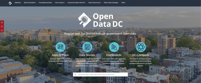
The release notes that after a successful 6-month private beta phase, DC Compass is now open for public testing. This beta phase is crucial for further gathering user feedback to refine the tool. The DC Government release states that they encourage users to explore DC Compass by visiting opendata.dc.gov and sharing their experiences and suggestions to help enhance its functionality.
A Future of Innovation and Collaboration
This launch represents not just a technological breakthrough but also a commitment to collaborative innovation in addressing the city's and its citizens' needs. As longstanding partners in technology to both the DC Government and specifically supporting the geospatial platforms across multiple agencies since the early days of the DC GIS Program, and Esri as a recent Cornerstone awardee, we celebrate this milestone and look forward to seeing how DC Compass will transform access to open data and civic engagement.
For a deeper dive into the DC Compass and the collaborative efforts behind it, please visit the official OCTO announcement here. Explore the potential of DC Compass together, pushing the boundaries of what’s possible with open data and AI in public service.
About New Light Technologies, Inc.
NLT is an innovative company that has been serving DC Government customers for over two decades with cutting-edge technology solutions. We are a leader in GIS, project management, systems engineering, and data analysis solutions, and our 20-year partnership with Esri solidifies our position as a cornerstone partner and leader in the industry. Our team of experts has diverse expertise that spans consulting and staffing for GIS, system architecture, web, and application development, among other areas, tailored to meet the evolving needs of clients.
You can discover NLT's work with the DC Government here, and learn more about our enduring partnership with Esri here, showcasing NLT's pivotal contribution to technological innovation and collaboration. NLT is committed to enhancing government initiatives with our cutting-edge technology and insights, and we look forward to continuing to serve our clients with the best solutions in the industry.
Read More: