

Clients
Federal Government

The U.S. Department of Agriculture (USDA) provides national and international leadership on agriculture, food, natural resources, rural infrastructure, nutrition, and foreign trade related issues through fact-based, data-driven, and customer-focused decisions. The department is organized into different mission areas that supply and depend on a complex array of information that the agency must efficiently manage to enable stakeholder collaboration to support these initiatives. These missions significantly rely on the collection, analysis, and dissemination of maps, geospatial data, remotely sensed aerial and satellite imagery, and other scientific information detailing topography, geology, crops, water supplies, farm properties, and much more. For example, the International Production Assessment Division (IPAD) within the Global Market Analysis (GMA) mission area uses satellite imagery and remote sensing data to assist in its agricultural estimates of global crop conditions. The division provides monthly estimates of area, yield and production for 17 distinct commodities in over 160 countries around the world, including post-disaster assessments.
To help the department realize its IT modernization goals to facilitate the efficient delivery of this information across the mission areas, NLT is leading the development and implementation of unified data search solutions for the Farm Production and Conservation and Trade and Foreign Agricultural Affairs missions, which include the Natural Resources Conservation Service (NRCS) and Foreign Agricultural Service (FAS). To do this, NLT and its partner Voyager Search, are implementing federated data integration, discovery, and dissemination solutions to index and link together disparate cloud-based and on-prem data holdings, including large repositories of imagery and geospatial data files that are used for a number of key public analytics dissemination systems such as the Global Agricultural Information Network (GAIN), Global Agricultural & Disaster Assessment System (GADAS), Crop Explorer, and the Geospatial Data Gateway. The solutions we are deploying are empowering user and analysts with the ability to perform a range of new spatial searches for rapidly retrieving a plethora of data including real-time crop conditions. This transformation is delivering a modern data architecture that will support improved information flow, security, and analysis to power the department’s data science in the future.

Implementation of Enterprise Data Search & Discovery Solutions Across USDA.
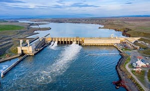
The U.S. Army Corps of Engineers (USACE) delivers engineering solutions, in collaboration with partners, to secure the nation, energize economies, and reduce disaster risk. An important part of the corps’ work involves the development, management, and dissemination of vital geospatial surveying, navigation, and hydropower data and tools that are relied on to support global missions across the federal interagency community.
NLT is leading multiple IT modernization initiatives to transform the corps’ legacy applications and technologies to new cloud-based serverless microservices architectures for enterprise surveying, mapping, and interagency data dissemination applications, including Survey Monument Archival & Retrieval Tool (U-SMART) and Civil Works Business Intelligence (CWBI) program. NLT’s unique expertise in these areas is enabling the agency to leverage modern cloud technologies that improve functionality, scalability, security, and performance while lowering ongoing costs and technical debt.
NLT is transforming U-SMART into a highly robust serverless application enabling offline distributed data collection, storage, and reporting of georeferenced survey control points and geodetic, tidal, and water level datums as part of the National Spatial Reference System (NSRS) for USACE, National Geodetic Society (NGS), US Geological Survey (USGS), and NOAA. NLT is also developing state-of-the-art open-source cloud-native solutions that enable the dynamic translation of disparate spatio-temporal civil works and waterway navigation data to facilitate interoperability between various open data APIs, RDBMSs, data feeds, and enterprise geospatial platforms, including USACE’s Common Operating Picture (UCOP), Data.gov, the GeoPlatfom, Esri ArcGIS Online, and other interagency systems.
Delivery of Digital Transformation Services for Critical Applications and Data Services.

To help the base standardize the collection and storage of various environmental information to improve interoperability and governance, NLT led the development and implementation of a Spatial Data Standards for Facilities, Infrastructure, and Environment (SDSFIE) compliant database. This involved building a data model to store the various environmental related data elements, migrating data into the model, performing quality control, and deploying the final database to the base’s enterprise GIS system. This work increased the accessibility and awareness of crucial environmental data and helped streamline operational workflows leading to improved efficiency.
Kirtland Air Force Base in Albuquerque, New Mexico is home to the 377th Air Base Wing of the Air Force Global Strike Command. The base and its various mission partners employs about 20,000 active duty, civilian, Guard and Reserve personnel and the sprawling base occupies over 50,132 acres of land with diverse landuse and environmental realms. The Kirtland Environmental Management Section manages a comprehensive program to ensure that base facilities comply with environmental laws and regulations related to air, water, petroleum storage tanks, hazardous material/waste, sensitive habitats, cultural resources, and more.

Environmental Data Standardization & Management Solutions.

The U.S. Census Bureau serves as the nation’s leading provider of quality data about its people and economy. For over ten years, NLT has been providing large-scale research, development, production, and management support to Research & Methodology directorate (R&M), Center for Economic Studies (CES), Longitudinal Employer-Household Dynamics Program (LEHD), Federal Statistical Research Data Centers (RDCs), and Center for Enterprise Dissemination (CED). NLT’s expert team of Economists, Geographers, Statisticians, Computer Scientists, and Cloud Engineers provide full lifecycle big data and digital transformation services including building national public data products, designing tools and applications for data visualization and analytics, managing critical computing infrastructure, developing novel privacy protection and disclosure avoidance methods, and more.
This work involves leading research, development and production of the nation’s primary economic datasets including the Business Dynamics Statistics (BDS), Dispersion Statistics on Productivity (DiSP), Job to Job Flows, LEHD Origin-Destination Employment Statistics (LODES), Quarterly Workforce Indicators (QWI), Synthetic Longitudinal Business Database (SynLBD), among others. These data products form a crucial part of the federal statistical infrastructure and are used to support a wide range of national and local planning and policy decisions, including those by the Council of Economic Advisors, and numerous academic initiatives.
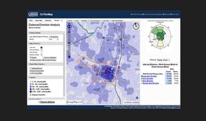
NLT has also delivered award-winning web-based analytics, visualization, and dissemination platforms for these data including QWI Explorer, J2J Explorer, LED Extraction Tool, OnTheMap for Emergency Management, and OnTheMap, for which the team received the Department of Commerce Gold Medal Award for Scientific/Engineering Contribution in 2012.

Delivery of Secure Public Data Dissemination Platforms.
NLT also leads the development and administration of the bureau’s state-of-the-art privacy protection solution, the Disclosure Avoidance System (DAS), which programmatically applies quadratically-optimized differential protection algorithms that provably safeguard confidentiality in all data released to the public.
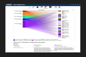
Economic Data Visualization Tool for U.S. Census Bureau: Job-to-job Flows Explorer
Economic Data Visualization Tool for U.S. Census Bureau: Job-to-job Flows Explorer

The U.S. Energy Department manages energy, environmental and nuclear challenges through the development and operationalization of transformative science and technology solutions. Leveraging our expertise in geospatial technologies and emergency management and natural hazards, NLT supported a contractor team preparing environmental impact studies related to the transportation and storage of nuclear reactor fuel. Our team developed geospatial models and tools to evaluate and visualize proposed rail transportation routes and potential risks and impacts from earthquakes, environmental, and other hazards.
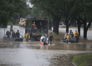
The Federal Emergency Management Agency (FEMA) coordinates the federal government’s role in preparing, preventing, mitigating the effects, responding, and recovering from all domestic disasters, natural, man-made, or acts of terror. For more than 15 years, NLT has served FEMA, providing a range of IT modernization and technical operational support services to facilitate the collection, analysis, and dissemination of disparate information to support decision making for a range of missions and incidents of national significance.
NLT’s interdisciplinary team of scientists and technologists provide comprehensive data science, systems engineering, training, and emergency management support to the National Preparedness Division (NPD), the Office of Response and Recovery (ORR), and the Office of the Chief Information Officer (OCIO) to architect and implement data-driven solutions to forecast incident conditions, identify community lifeline risks, assess damages, prioritize resources, guide search and rescue operations, and more.
Over this time, we have pioneered award-winning, cloud-based, open-source solutions for automating hazard detection and modeling, risk and exposure analysis, AI/ML-based predictive analytics, damage assessments, resource planning, and the development of real-time situational awareness and decision support systems that provide enhanced operational intelligence.
NLT FEMA Clients At A Glance:
Integrated Science, Digital Transformation, Data Analytics, & Disaster Support.
The Center for Domestic Preparedness
The Center for Domestic Preparedness provides advanced, all-hazards preparedness, protection, and response training to approximately 50,000 emergency responders annually from state, local, tribal, and territorial governments, as well as the federal government, foreign governments, and private sector organizations. NLT supports the development and hosting of advanced online geospatial mapping tools for hazard training scenarios, exercises, and courses.

Cloud-hosted Training Solutions for FEMA Center for Domestic Preparedness (CDP).
The National Integration Center
The National Integration Center develops guidance and tools to assist communities with preparedness challenges and coordinate the adoption and implementation of a common incident management platform for emergency responders and officials. NLT provides comprehensive IT modernization support for the development of an integrated National Resource Hub unifying information on available personnel, equipment, teams, supplies, and facilities.
The Response Geospatial Office
The Response Geospatial Office leads the development and maintenance of all-hazard, risk-based geospatial and data analytic modeling and simulation capabilities to support national preparedness directives and response and recovery missions. NLT provides integrated cloud, data science, systems engineering, training and coordination support for the implementation of real-time analytics and information products, web-based decision support tools, and information management and dissemination platforms to support incident response planning and operations.
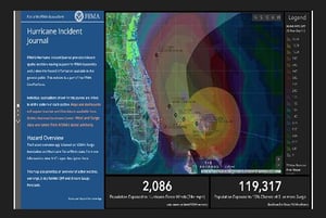
FEMA Web-based Hurricane Incident Journal.
Logistics Management
Logistics Management Directorate oversees effective and efficient distribution of supplies, equipment and services in response to domestic disasters and emergencies. NLT provides support for the development and maintenance of maps, plans, information products, and web-based decision support tools to streamline logistics operations.
Office of the Chief Information Officer
FEMA’s Office of the Chief Information Officer provides secure enterprise IT services to ensure its stakeholders and workforce can lead the nation in preparing for, protecting against, responding to, recovering from, and mitigating all hazards. NLT provides full lifecycle operations, sustainment, and modernization support for enterprise cloud-based information systems infrastructure powering the flow of data to agency systems, websites, mobile apps, and more.
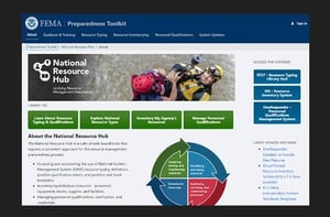
Development of Unified National Resource Hub for Disaster Preparedness.
The Federal Communications Commission (FCC) implements and enforces U.S. communications regulations for radio, television, wire, satellite, and cable. Part of this mission involves collecting and publishing information about mobile and broadband network service availability across the U.S. To help the department fulfill this mission, NLT supported a contractor team in designing and implementing a new web-based mapping system providing consumers, policymakers, and other interested stakeholders better access to dynamic mobile and broadband deployment information and aid in advancing the FCC’s and state and local government efforts to close the digital divide.
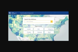
Implementation of Public Web-based Application to Access Broadband and Mobile Network Availability Data.
State & Local Government

NLT has provided information technology consulting, digital transformation, and operational support services to District of Columbia agencies for over 20 years. The firm’s interdisciplinary teams support a wide range of projects and initiatives to help the district leverage technology and data science to improve delivery of critical services to citizens. From implementing state-of-the-art mobile computing solutions for public safety personnel to building the district’s innovative healthcare exchange platform, NLT has delivered services and award-winning solutions to get the job done. NLT has built an impeccable record as a trusted partner for agency missions in the nation’s capital including:
DC Clients At A Glance:
Health Benefit Exchange Authority
Design, development, and sustainment for the district’s health insurance platform DC Health Link.
DC-Net
Full lifecycle development and management of the district’s state-of-the-art mobile-enabled fiber network infrastructure management platform that enables delivery of broadband service.
DC Office of the Chief Technology Officer
Design, development, and sustainment of enterprise platforms including the award-winning DC Guide web portal.

Integrated Science, Technology & Digital Transformation, & Mission Services.
DC GIS
Development of delivery of key datasets and dissemination platforms including the Master Address Reposit (MAR), parcel and planimetric maps and numerous online geospatial visualization tools.
DC Metropolitan Police Department
Design and implementation of in-vehicle mobile computing solutions enabling real-time communication, tracking, and analytics for DC’s police, fire, and medical services.
Department Of Consumer And Regulatory Affairs
Modernization of department systems to enable streamlined workflows, enhanced reporting, route optimization for field inspectors.
Department Of Transportation
Design and implementation of enhanced solutions for street inventorying, Right-of-Way management, automated vehicle tracking (AVL), collection of 360˚ street-level imagery surveys, and more.
Office Of Zoning
Design and development of the nation’s first official digital zoning map served through web-based mapping application and data services.

Implementation of Public Web-based Application to Access Broadband and Mobile Network Availability Data.

NLT provides modernization, secure hosting, and maintenance for the Louisiana Department of Health (LDH) facilities mapping and analytics application. NLT led the transformation of legacy on-premises systems to a state-of-the-art unified cloud-based application leveraging serverless design patterns that reduce use and maintenance of expensive and inefficient server-side software components for processing and retrieval of map data. The new application offers a suite of interactive tools enabling LDH personnel to quickly identify facilities and service populations, generate reports, and assess and plan for impacts from hurricanes in real-time.
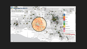
LDH cloud-native Facilities Mapping and Analytics Application.
With over 200 million rail and bus trips per year, the Washington Metropolitan Area Transit Authority (WMATA) manages the second-busiest rapid transit system in the U.S. The management of such a massive transit network and operation requires secure and rapid access to digital documents, plans, maps, images, and records on stations, routes, properties, buildings, and equipment, for daily operations. To modernize the agency’s management of disparate information, NLT provided consulting services supporting the design and implementation of a new Electronic Document Management Solution (EDMS) to optimize indexing, searching, access, retrieval, display, and sharing of structured and unstructured data resulting in streamlining of workflows, lower costs, and improved service.

Modernization of WMATA Enterprise Document Management Solutions.

NLT has supported a range of transportation projects for the state’s Highway Administration, Aviation Administration, and Baltimore/Washington International Thurgood Marshall Airport. This work involves the collection, development, and quality control of key datasets and geospatial analyses required for the state’s transportation master plan and BWI expansion projects and their integration into the state’s enterprise databases and GIS systems.

The Maryland-National Capital Park and Planning Commission (M-NCPPC) is a regional landuse, park, open space, and recreation system administrator within Montgomery and Prince George’s Counties. To carry out this responsibility, M-NCPPC performs a range of functions including maintaining park properties, assessing community needs, reviewing development proposals, and preparing master plans that guide regional development that rely on detailed maps and databases. To help the commission modernize their geospatial information systems and databases to improve operational efficiencies, NLT led a range of digital transformation services including data engineering, database migration, web platform enhancement, and training. The newly designed and implemented enterprise infrastructure provided a unified data infrastructure and new analytical tools and workflows for streamlining the planning process and production of studies and reports for the public
Successful urban and wildland fire prevention and response is vital to the communities and environment in and around Flagstaff AZ. To do this effectively, fire stations and facilities must be optimally located throughout the community to ensure rapid response times to all service areas. To study this and develop a plan for where to locate stations, the city turned to NLT, a leader in the development of data-driven solutions for municipal government. Leveraging its expertise in Geographic Information Systems (GIS), NLT designed a multi-variate spatial model evaluating population density, property locations, street networks, environmental data, and a range of emergency response time scenarios to develop recommendations on optimal site locations for stations and resources throughout the city.
Non-Profit & Community-Based Organizations

The World Bank Group is one of the world’s largest sources of funding and knowledge for developing countries, promoting sustainable solutions that reduce poverty and build shared prosperity in the developing world. With extensive experience in supporting and leading applied research and science, NLT provides several divisions at the World Bank support and guidance implementing information technology, geospatial and data science solutions for various research and development initiatives. Our interdisciplinary team of Economists, Geographers, Computer Scientists, and Statisticians lead the design and implementation of data-driven solutions to support and enhance land management, agriculture, economic development, transportation planning, and disaster response projects in developing nations throughout the world. In support of these projects, NLT has pioneered innovative methods and tools exploiting free and open-source satellite imagery and other geospatial data to monitor urbanization processes, crop health, natural hazard risk, and more. Details about these innovations have been reported in numerous peer reviewed journals and papers, a sampling of which are available on the NLT Publications page.
NLT World Bank Work at a Glance:
Land Use/Land Cover Mapping:
Identification of land use transitions and their socio-economic impacts in South Asia and Africa; An Analysis of land use change in Laos and Zambia; Processing spatial data land use changes in Ethiopia and Malawi.
Web-based Dashboards & Storymaps:
Geospatial Data for Urban Resilience: Utilizing the StoryMaps Platform to Communicate Geospatial Data for a Stronger Urban Resilience; Analysis and development of StoryMaps to inform the Flood-Resilient Mass Transit Planning in Ouagadougou, Burkina Faso Analytical and Advisory Activity (ASA).
Flood Detection for Resilience:
Towards a Scalable Operational Tool for Flood Exposure Estimations in Sierra Leone, Madagascar, Vietnam; Urban Flood Mapping with Open-Source Methods: Leveraging Geospatial Data for Resilience; Detection of Urban Flooding with Open-Source Data and Methods (multiple developing cities); AI for Public Asset Management: Flood Tracking from Emerging Economy Cities. The Case of Maharashtra, India.
Satellite Imagery ML Solutions for Monitoring Urbanization and Economic Dynamics.
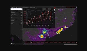
Tracking Economic Activity and Economic Trends:
Assessing Economic Activities Around Transportation Corridors in BBIN Countries (Bangladesh, Bhutan, India and Nepal); Measuring Spatial and Temporal Economic trends in Nepal; The Urban Economic Impacts of COVID-19 in the Middle East & North Africa (MENA): Near-Real-Time Tracking of Economic Activity and its Relation to the Pandemic using Nighttime Lights Data; East Asia & Pacific Satellite Sum of Lights (SOL) Socio-economic Observatory; Time-Series Analysis of Three Decades of Nighttime Light Data: A Robust Tool for Inter-calibration between DMSP-OLS and VIIRS Nighttime Light Data; Country Diagnostic Enhancement, Transportation Corridors and Economic Development in Asia; Assessing Economic Activities in Conflict-Affected Areas: The Case of Myanmar; Assessing Economic Activities Around Transportation Corridors: Evidence from International Development Organizations ; Country Diagnostic Enhancement, Transportation Corridors and Economic Development in India and Asia.

Integrated Science, Research, Digital Transformation, & Training Services for Sustainable Development & Climate Change Resiliency.
Data Management:
Assessing Tax Gaps and quality of cadastral records in Lesotho, Tanzania, Zambia, Vietnam and Ukraine; Assessing the Completeness of OpenStreetMap in Nepal.
Risk & Exposure Assessment:
Remote Sensing and AI Applications for Risk and Exposure Assessment; Assessing OSM Completeness for Management of Natural Disaster by Means of Remote Sensing: A Case Study of Three Small Island States; Future River Basin Flood Risk and Recurrence: Towards a Scalable Operational Tool for Flood Exposure Estimations; High-Resolution Geospatial Data for Decision-Making and Disaster Risk Management in coastal Bangladesh.

Capacity Building Through Delivery of Data Science & Geospatial Curricula and Training Courses for International Development.
Governance:
Open Cities Satellite Mapping and Analytics for an Effective City Governance; Timor Leste: Open Satellite Data Feeds for Economic and Public Sector Governance Management.
Sustainable Development:
Utilizing Remotely Sensed Observations to Estimate the Urban Heat Island Effect at a Local Scale: Case Study of a University Campus.
Development of Data Models and Tools Providing Insights About Resiliency of Communities Worldwide.
The Carlos Rosario School is an independent international charter school providing quality education to the diverse immigrant population of the District of Columbia through English as a second language, workforce development, and support services. NLT helped transform the school’s information and reporting systems by developing a unified database query framework and series of Tableau dashboards make it easier for administrators to quickly perform queries, link related information, and generate and share reports on a range of student and school program related information.

Child Trends is a non-partisan research center dedicated to improving the lives of children and youth by conducting high-quality research and sharing it with the people and institutions whose decisions and actions affect children. NLT provided research and analytical support for major studies that assess education needs in different regions. Leveraging our deep expertise in data science and spatial analysis, NLT integrated data from the U.S. Census Bureau, National Center for Health Statistics, and other sources to determine the density and distribution of various socio-economic segments of children across study areas to identify needs and inform education policy.

The Golden Triangle Business Improvement District (GTBID) is a non-profit organization established to support the sustainable economic development and delivery and maintenance of services, for a large area of downtown Washington DC, through capital improvement projects and public events. To support this mission, NLT developed a mobile GPS-enabled street asset management system to enable GTBID to collect information about the needs of customers and the condition and availability of business services and physical assets within the district. Collaborating with DC government, the Metropolitan Washington Council of Governments (MWCOG), and the Downtown Business Improvement District (DBID), NLT designed and implemented streamlined data collection and processing workflows capable of capturing and communicating dynamic information about assets and needs to enable more rapid and successful delivery of services for businesses.

The Joint Center for Political and Economic Studies provides evidence-based research to support actionable policy solutions to advance Balck communities in America. NLT provided research and analytical support for studies into the geography of political participation levels across the US and southeastern US. Leveraging our deep expertise in data science and spatial analysis, NLT integrated data from the U.S. Census Bureau, states, and other sources to illuminate how geographic factors such as distance and driving time to polls affect participation in different communities.

The National Trust for Historic Preservation is a privately funded nonprofit organization supporting the preservation of America’s diverse historic buildings, neighborhoods, and heritage through its programs, resources, and advocacy. To help the Trust carry out this mission and enable the centralized communication and visualization of information about historic properties, NLT developed a web-based mapping and reporting application. The new system provided a intuitive interface for searching and locating historic sites across the US on a map and viewing useful property information including addresses, operating hours, driving directions, pictures, and other information of interest to visitors.
Commercial

JMT is a leading national planning, design, and construction management services provider. NLT has provided geospatial, data science, and software development services to JMT in support of a range of transportation engineering projects across Maryland.

Information Builders Inc., now TIBCO, is a leading provider of Data Integration, Data Quality, and Business Intelligence software solutions used by organizations worldwide. NLT provided systems integration support for implementation and customization of IBI-based platforms to connect disparate data portfolios for the Maryland Department of Motor Vehicles. The results of this work provided the DMV workforce increased workflow efficiencies and enhanced dashboarding and reporting capacity that led to improved customer satisfaction.

The Louis Berger Group (LBG), now WSP, is a global architecture, planning, engineering, and environmental services firm leading large planning and infrastructure development for water and transportation projects worldwide. NLT provided LBG software engineering support services for the development of a web-based Public Comment Console to help public utilities facilitate and incorporate public input about proposed utility transmission projects. The system provided a central database with easy-to-use web tools for concerned citizens and stakeholders to submit, query, and report comments and enabled LBG to more effectively plan and conduct public outreach campaigns.

Mapbox is the leading provider of Software Development Kits (SDKs), Application Programming Interfaces (APIs), and data platform services for the development of live mapping and location based applications. NLT provides cloud implementation, platform customization, and advanced data science related services supporting different software and data products including Atlas and Movement Data. NLT’s deep expertise in designing real-time data pipelines and automated cloud deployment solutions has helped advance Mapbox’s product lines to be more scalable and secure for customers.

Paymerang provides streamlined invoice and payment automation solutions through cloud and AI technologies. NLT provides cloud automation and software engineering support services for the modernization of the invoice and payment platforms to enable continuous software delivery, improved systems scalability, and processing performance.

Owens & Minor, Inc. (NYSE: OMI) is a global healthcare solutions company that incorporates product manufacturing, distribution support, and innovative technology services to deliver surgical and PPE products and medical supplies to customers worldwide. NLT provides a range of cybersecurity and IT modernization services for the implementation of more secure, standards-compliant computing infrastructure for the future. Leveraging its unique expertise building automated security compliance solutions for cloud environments, NLT is supporting O&M attain accreditations through the design and deployment of advanced security controls that enable continuous threat detection, remediation, and monitoring in Azure.

Revolution Energy Solutions, LLC delivers clean energy solutions to the agriculture and agri-foods industry through recycling waste into value while reducing the emissions of greenhouse gases and other harmful waste by-products. NLT provided comprehensive software engineering services for the development of the Renewable Energy Site Selection Application (RESSA) which facilitates identification of optimal locations to convert high-emission agricultural operations into renewable energy projects. Leveraging our expertise in web-based software development, government data, and spatial analysis, we designed and implemented a site selection solution incorporating National Renewable Energy Laboratory (NREL) information to support streamlined evaluation of energy investment alternatives.

Social Knowledge provides collaborative online communities where people with similar interests connect to harness the distributed expertise of the members. Communities range from travel to cooking to health and wellness and provides discussion forums, wikis, maps, and tools to facilitate communication. NLT provides software engineering and geospatial services supporting the integration of location intelligence and mapping solutions into the community sites. This support includes the development of web-based trip planning and routing tools for recreational vehicle (RV) community sites.

Wood is a leading global provider of consulting, engineering, and technical services for sustainable energy and built environments. NLT provides geospatial and data science services to support Woods analysis and mapping of flood prone areas and the creation of FEMA’s Digital Flood Insurance Rate Maps (DFIRMs) for Maryland. NLT data scientists utilize GIS, data modeling, and software programming to assess a range of topographic, hydrologic, infrastructural, and other information to generate and update flood maps to enable improved resiliency of communities.
Academia

Project Spotlight | Linking Neuroimaging and Mental Health to Satellite Imagery Measurements of Macro Environmental Factors
Over the last decade, several studies have highlighted the significant influence of environmental factors on mental health globally. However, data on physical surroundings remain limited. Access to such data and the ability to link them to epidemiological studies are critical for unraveling the relationship between environment, brain, and behavior, and for promoting positive future mental health outcomes. Funded by Georgia State University and in collaboration with leading universities both within and outside the US, NLT's team of researchers and data scientists co-authored a pioneering literature review. This review summarizes the most recent studies linking environmental factors with mental health. Additionally, the study utilized the Adolescent Brain Cognitive Development (ABCD) Study—the largest ongoing longitudinal and observational study exploring brain development and child health among children from 21 sites across the United States. The team linked ABCD study data with satellite-based variables, consisting of 11 satellite-data-derived environmental indicators associated with each subject’s residential address, including land cover and land use, nighttime lights, and population characteristics. The study has highlighted and discussed significant links between satellite data variables, the default mode network clustering coefficient, and cognition. This study and its associated data lay the groundwork for large-scale environmental epidemiology research.

Project Spotlight | Geo4Dev
With the increased availability of a wide range of diverse geospatial data about developing countries, including aspects related to poverty and other societal characteristics, economic trends, food security, changes to ecosystems and geospatial indicators of society well-being or inequality, new tools and methodologies are being developed and made available and accessible to sectors who traditionally did not rely or knew how to make sense of geospatial data. In parallel, much effort is put towards capacity building and development of basic training on the use of geospatial data, applications and tools to promote a more sustainable environment and society.
A collaboration between NLT, the Center for Global Action (CEGA) and 3ie, the Geospatial Data for Development (Geo4Dev) aims to drive the development of new data, tools and methods for conducting geospatial analysis across diverse sectors, including agriculture and food security, urbanization, climate change, impact evaluation, humanitarian crisis, and disaster response. It brings together a network of leading researchers, government ministries, NGOs, private enterprises, and funding partners to inspire and support new research collaborations, share knowledge, and build capacity to utilize geospatial data, tools, and approaches. Geo4Dev aims to provide a hub that inspires and supports new research collaborations, share knowledge, and build capacity to utilize geospatial data, tools, and approaches to measure all aspects of developing countries.
Project Spotlight | The Remote Sensing in Disasters Community of Practice (REDICOP)
Co-organized by MIT Lincoln Laboratory (MIT LL) and NLT, the Remote Sensing in Disasters Community of Practice (REDICOP) was established in 2023. REDICOP seeks to optimize the application of remote sensing advancements in the emergency management community, acting as a bridge between theoretical and applied research, and operational implementation. With partners from Federal, State, and local agencies, public sector research groups, NGOs, academia, and the private sector, the initiative focuses on building a collaborative platform to advance remote sensing technologies and methods in disaster management and on development of guidelines, standards, and workflows that enable emergency managers to use remote sensing technologies and products effectively. It provides a unique bridge between theory and practice and between academia, government and the private sector, bringing together stakeholders from all sectors with one mission in mind- to optimize the use of remotely sensed tools and data to improve disaster management operations and eventually save lives.
NLT offers a comprehensive range of services to support cutting-edge scientific research at leading universities, ensuring the successful and smooth implementation of scientific research, novel technologies, and applications. Our broad science and technology expertise enables us to incorporate innovative datasets and groundbreaking methodologies to support high-quality scientific research and development. NLT is also committed to training the next generation of data scientists, preparing them for a competitive job market. This goal is achieved by partnering with universities, research centers, academic programs, and private schools, allowing students to leverage their skills to address real-world use cases and develop innovative, data-driven solutions to some of today's most pressing challenges. With nearly twenty percent of NLT's staff holding PhD degrees or having formal academic teaching or research experience, NLT has established a reputation akin to a research institute. Our staff provides mentorship to students, presents at leading conferences, and is constantly involved in academic writing and groundbreaking research.
Project Spotlight | Dynamic Infectious Disease Risk Platform for Decision-Makers
Dengue fever, a common and spreading arboviral disease, poses significant public health and economic challenges in tropical and subtropical regions. The World Health Organization (WHO) reports that since the beginning of 2023, there has been an increase in dengue cases and deaths in endemic areas, extending to regions previously unaffected by the disease. As dengue fever is influenced by climatic factors, variations in temperature and rainfall significantly affect its transmission's magnitude and seasonality.
In 2023, the Wellcome Trust awarded UC San Diego's School of Global Policy and Strategy (GPS) a five-year grant to develop and deploy, in collaboration with NLT and UNICEF, a Dynamic Infectious Disease Risk Platform. This platform aims to provide decision-makers, emergency responders, governments, and public health agencies a data-driven predictive tool. The platform will utilize an ensemble machine learning model developed by UNICEF and ESA, featuring a geospatial display, tabular data, and summary statistics of both predicted and historical Dengue fever cases. Through real-time data feeds, along with the analysis of climatological, environmental, and socio-economic and demographic indicators, the platform will inform decision-makers about predicted spikes in dengue fever transmission rates and provide the means to estimate the public health resources needed for disease prevention and treatment.

Project Spotlight | Data Science Immersive Client Project
For several years, NLT has trained the next generation of data scientists through the General Assembly to make better decisions through data. More than 100 students across ten of General Assembly`s campuses in the U.S. were challenged to find innovative ways to utilize technology and big data to address some of the most fundamental problems of today's world. This partnership has resulted in more than 20 innovative student projects that bring together state-of-the-art theories in data science, artificial intelligence, machine learning and open-source data to improve decision-making during disasters. Through their work, these students have developed tools introducing some groundbreaking concepts into the realm of disaster response operations.

Project Spotlight | Google Earth Engine for Urban Applications
Emerging cloud-based computational platforms now enable the scaling of geospatial analysis across space and time. Google Earth Engine (GEE) is one such platform that utilizes cloud-computing services to facilitate planetary-scale analyses. GEE provides access to petabytes of geospatial and tabular data, including comprehensive archives of Landsat, Sentinel-2, Sentinel-1, and MODIS. It also offers a JavaScript and Python-based API (GEE API) and algorithms for supervised image classification.
Collaborating with the University of North Carolina, NLT's team of scientists has taught a hands-on course focused on using GEE for urban research applications. The course demonstrated how free and open-source satellite imagery—including electro-optical (EO) and Synthetic Aperture Radar (SAR) imagery—can be utilized to map urban areas and trends in urbanization across space and time. It also covered performing qualitative analyses of the impacts of urban expansion on the landscape. The course provided an introduction to concepts in Remote Sensing and Machine Learning, with a particular emphasis on supervised pixel-based image classification. Students learned how to automatically map built-up land cover using publicly available satellite imagery. Additionally, the course showcased recent innovations in using remotely sensed nighttime light observations to understand variations in economic activity within and between cities, all through the data and tools available in GEE.