Parts of this blog were published in the World Bank`s Data Blog in collaboration.
SUBMITTED BY RAN GOLDBLATT
CO-AUTHORS: KAI KAISER, HUONG THI LAN TRAN, KIEN VU
Blog contributors include NLT Chief Scientist Ran Goldblatt & NLT Telco Program Manager Jason Longenecker
Satellites provide daily images of almost every location on earth, and computers can be trained to process massive amounts of data generated from them to produce insightful analysis/information. This is just one of the demonstrations of artificial intelligence (AI). AI can go beyond just reading images captured from space; it can help improve lives overall.
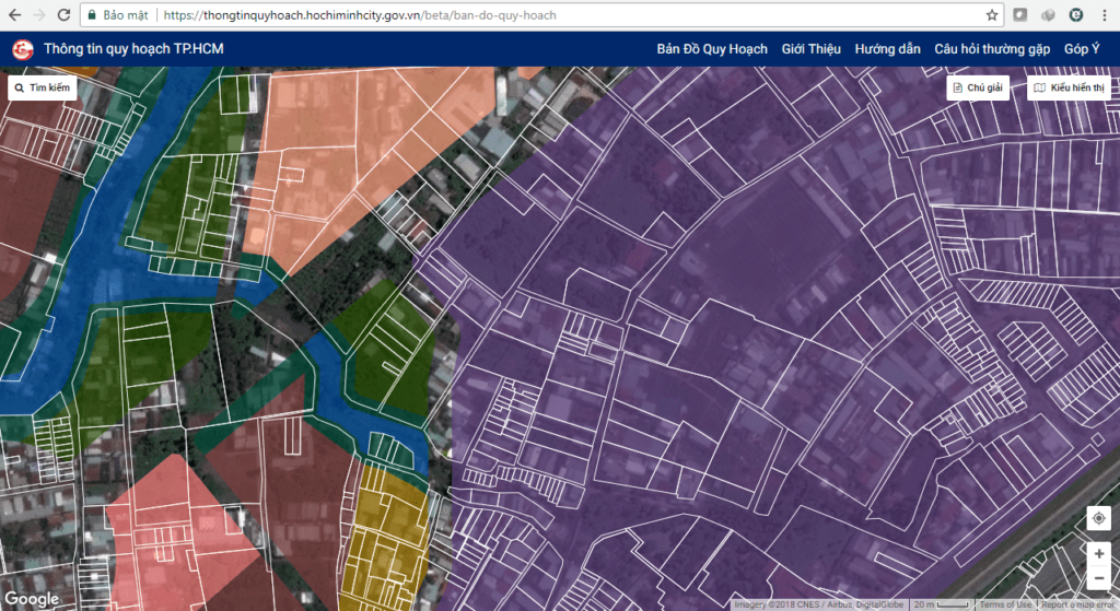
Machine learning and AI are increasingly used to provide near real-time analysis of how cities change in practice. However, by teaching computers what to look for in satellite images, rapidly expanding sources of satellite data (public and commercial), together with machine learning algorithms, can be leveraged to quickly reveal how actual city development aligns with planning and zoning.
An ongoing collaboration between the World Bank’s Governance and Land & Geospatial Teams, together with the Development Economics Research Group, is helping connect emerging technology and machine learning to key development stakeholders in Ho Chi Minh City (HCMC), Vietnam. Specific types of machine learning algorithms “teach” computers to automatically detect and classify different types of land cover and land use across space and time, and then generate compelling insights, analytics and visualizations. The machine predicts later the spatial distribution of these types of land cover and land use, and this prediction can then be analyzed and translated into smart city management.
“In today`s world of technological advancements, NLT plays an increasing role in helping organizations, developing countries and importantly- vulnerable communities – harness these new technologies for the benefit of the citizens. A recent example is an ongoing project with the World Bank aiming to develop innovative tools to empower decision-makers in vulnerable countries to strengthen their resilience,”
- Ran Goldblatt, NLT Chief Scientist and Senior Consultant
Technology Has Made It Easier To Access And Process Satellite Imagery
The traditional model of using satellite imagery was getting a very small subset of it on a Compact Disk and analyzing it on a local computer. But increasingly, this data is brought to the cloud, avoiding the need to download large out of date volumes of satellite data. Cloud-based platforms, also include machine learning algorithms that can be utilized to analyze millions of scenes on a global scale.
AI will never replace human validation or effective governance on the ground. But satellite data, together with machine learning, can provide a bird’s eye view down to the minutiae of what is happening on the ground and what requires further attention. Smart Cities like HCMC can take bright steps to harness this technology by first using free data and learning by doing. Sharing and communicating these results with a broader set of stakeholders in and out of government will trigger those solutions that promise to make the most significant difference in people’s lives.
NLT Understands How Technology Can Be Used To Help Communities Thrive

New Light Technologies, Inc. (NLT) offers deep experience integrating modern technologies with different disciplines including urban planning, public safety, transportation, economics, environmental conservation, community broadband networks and more to implement successful solutions to benefit all citizens.
“We take great pride in helping community broadband providers streamline their fiber mapping, plant estimating processes and reduce the workload of engineers,” - Jason Longenecker, NLT Telecom Project Manager
NLT developed a new, easy to use Linear Asset Management System that enables small broadband providers to:
- Mapping and visualization of physical assets (such as cable, poles, manholes and other “networked assets” such as water and electrical supply systems)
- Efficient and transparent network design and planning
- Generate and validate network routes in seconds
- Fast fault detection to reduce response time
- Desktop engineering tools that reduce truck rolls and labor costs.
Our technology and consulting practice has enabled Cities like Washington, DC with their DC-Net program to bring affordable, value-added broadband services to over 600 critical health, educational, public safety, and other community anchor institutions throughout Washington, DC.
NLT knows that a Smart City, needs a smart network and that you need smart tools to build and maintain it. NLT Utility LINE, allows its end users to map, track, analyze, report on, and manage their operational support systems.
What Utility LINE ® Offers?
- GIS and Mapping Tools
- Physical Network Planning & Work Order Support
- Network Cabling
- Custom Integrations
- Users and Roles
Improved Zoning Information Access Makes Cities Smarter
NLT over the years has worked with the DC Office of Zoning in developing the first generation of its Official Digital Zoning Map in the USA using tightly integrated geospatial application development. The city has continued to grow its zoning information sharing and collaboration and has seen net benefits to its operations and more importantly, the user community inside and outside government.