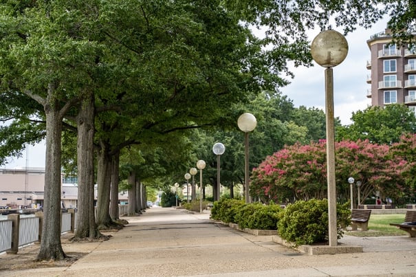
Urban trees are a crucial component of cities' environmental sustainability, contributing to various environmental, climatological, and social aspects of urban life, including human health, mitigation of the urban heat island effect, and maintaining overall ecological balance. Urban trees assist in lowering energy costs, lowering air pollution, and increasing property values while reducing crime. Maintaining a robust and sustainable tree canopy in densely populated cities like Washington, D.C. is both challenging and necessary. The D.C. government has stated that it aims to achieve 40% tree coverage by 2032, a goal that requires detailed and continuous monitoring of the city’s trees.
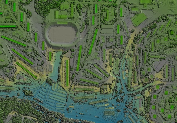
A recent study by New Light Technologies (NLT), A DC-based Geospatial Data Science company, explored the effectiveness of Light Detection and Ranging (LiDAR) technology in detecting and estimating urban tree heights. Focusing on Ward 7 in Washington, D.C., this research sheds light on how LiDAR can enhance urban forestry management by providing precise data on the distribution of trees, their heights and canopy structure.
Understanding the Role of LiDAR in Urban Tree Management
Tree canopy is defined as the layer of leaves, branches, and stems of trees that cover the ground when viewed from above. LiDAR, a remote sensing method that uses laser pulses to generate precise, three-dimensional information about the shape of features on Earth, has become increasingly viable for urban tree canopy assessments. This technology allows not only the detection of individual trees but also the measurement of canopy height, which is crucial for various aspects of tree maintenance, including monitoring growth, planning new plantings, and assessing the impact of trees on urban environments.
In Washington, D.C., the urban forestry division maintains a database of nearly 175,000 city-managed trees. However, this database primarily includes basic information such as tree species and locations and needs continuous data on canopy heights. This gap in data can hinder effective tree management, especially as the city strives to meet its ambitious canopy coverage goals.
The Study: Ward 7 as a Case Study
The research concentrated on Ward 7 in Washington DC, an area located in the easternmost part of the District of Columbia, including Kingman Park and Hill East neighborhoods. The Ward is renowned for its green spaces, leafy streets, and single-family homes, including historic parks and the Anacostia River Park, which has 89,870 residents. Between 2010 and 2020, the Ward`s population grew from 71,748 to 76,255 people, an increase of 6.3%.
However, the Ward`s population faces considerable vulnerability challenges related to safety and physical and social health. Effectively managing green infrastructure could help address these issues. Using LiDAR data collected in 2015 and 2020, we can identify individual tree locations using tree-finding algorithms and evaluate the performance of LiDAR in estimating tree heights. NLT`s research team sought to answer three key questions:
- Can LiDAR effectively detect tree locations in a densely populated urban area?
- Can LiDAR accurately estimate tree heights, and how does it compare to measurements conducted using traditional methods, such as ground surveys?
- Can LiDAR be used to estimate changes in tree height over time?
Key Findings and Implications
The study's results are promising. Our algorithm can effectively detect individual urban trees above 2 meters, with the 2020 LiDAR data successfully identifying 47.6% of known trees in Ward 7 (with a lower detection rate of 32% using 2015 LiDAR data). The study also found a strong correlation between LiDAR-derived tree heights and reference measurements, particularly in the 2020 data, which showed an R² value of 0.79.
One of the critical insights from the research is the potential for using LiDAR to monitor changes in tree height over time. This capability is particularly valuable for urban forestry management, allowing city planners to track tree growth, assess the effectiveness of tree maintenance programs, and plan future plantings with greater accuracy. Additionally, the research identified an inconsistency in tree location data between LiDAR and the D.C. government’s tree database, suggesting an opportunity to further refine existing tree detection methods currently used by the city`s Urban Forestry Division.
The Future of Urban Forestry in D.C.
The District of Columbia Urban Tree Canopy Plan suggests that an increase of 5% in canopy cover across the city could provide $4.2 million dollars annually in benefits to the city by improving air quality, reducing stormwater volumes, trapping greenhouse gasses, reducing the urban heat island effect, and increasing tourism and property values. Managing and monitoring a city`s tree cover is essential for ensuring its sustainability. The findings of this study underscore the importance of continued investment in LiDAR technology and its integration into urban forestry management. As cities like Washington, D.C., strive to enhance their green spaces and tree canopy, accurately measuring and monitoring tree canopies will be crucial in achieving sustainability goals and improving human quality of life.
 Moreover, the study suggests that LiDAR could play a significant role in broader environmental initiatives, such as biomass estimation, carbon sequestration, and environmental justice. As urban areas continue to grow and as they become more densely populated, the need for precise, data-driven approaches to managing natural resources will only become more critical. The use of LiDAR in urban tree canopy management offers a promising avenue for cities to enhance their green spaces, improve environmental quality, and ensure a healthier, more sustainable future for their residents.
Read the full case study on our publications page.
About NLT
New Light Technologies, Inc. (NLT) is a leading provider of integrated information technology, technical, scientific, consulting, and research services based in Washington, DC. NLT provides a broad range of integrated cloud, agile software development, cybersecurity, data science, geospatial, and workforce services and ready-to-use solutions for customers and offers distinctive capabilities in developing secure cloud-native AI/ML data analytics and decision support tools. The firm also provides unique expertise in designing, implementing, and managing enterprise solutions that enable the collection, integration, modeling and analysis, privacy protection, quality control, visualization, and public release of large-scale datasets and web-based data dissemination platforms. Contact us for more information and set up a conversation with our team members about this and other related work we do in climate-related projects at the local, national, and global levels.
