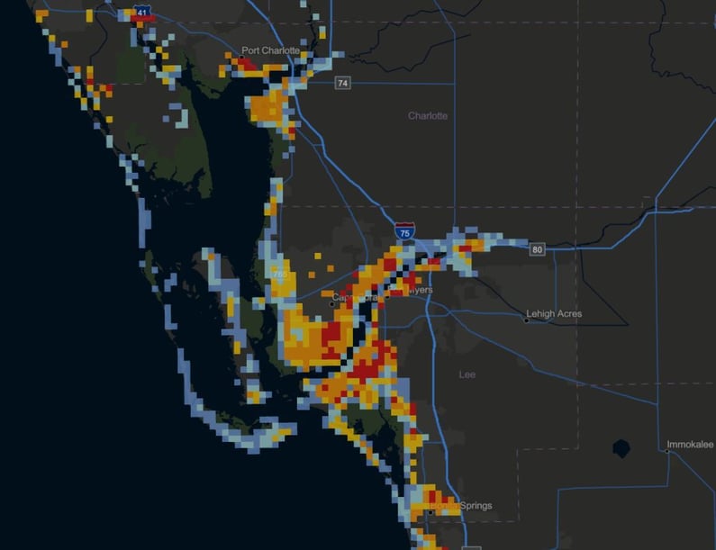
Hurricane Ian, which made landfall in Florida in late September 2022, was the strongest hurricane to hit Florida since Hurricane Michael in 2018 and the first Category 4 hurricane to impact Southwest Florida since 2004. Ian impacted parts of Florida’s western coast with heavy rainfall, and catastrophic storm surges with inundation of up to 12 -18 feet above ground level at some areas. Over 100 lives were lost, and communities across the state were left with catastrophic flooding damage.
Earlier in 2022, Eastern Kentucky and central Appalachia experienced heavy rain, deadly flash flooding, and devastating river flooding. Rainfall rates exceeded 4" per hour across complex terrain, leading to widespread devastating impacts. The overwhelming amounts of rain and resultant flooding led to 39 deaths and widespread catastrophic damage.
With climate change, such events are not rare in recent years. Extreme weather events, sea level rise, and other climate change impacts are exposing more and more vulnerable people and communities to extreme floods. In 2021 alone, floods and flash floods caused over three billion U.S. dollars worth of property and crop damage across the United States, up from around one billion U.S. dollars worth of damage in the previous year.
During catastrophic flood events, first respondents must quickly understand their nature: How many people are within the flooded area? Which communities are at risk or have been affected? Which critical infrastructure may be impacted? How many structures have been exposed to significant floods?
Satellite observations can provide a real-time glimpse into the spatial distribution and severity of floods and their impacts upon communities. However, one of the challenges of mapping floods is the significant cloud coverage that often impacts the flooded areas. Traditional satellite-based Electro Optical (EO) sensors cannot penetrate the clouds, limiting their utility for disaster response operations - at least in the initial phases of a flood event. On the other hand, Synthetic Aperture Radar (SAR) is particularly helpful compared to other modes of remote sensing, since its radar transmission in the microwave spectrum is independent of day-and-night visibility and weather conditions, such as persistent rain and cloud cover observed during typhoons. Thus, access to high-quality high-resolution and frequent SAR imagery is key for effective disaster response and recovery operations.
In the United States, the Federal Emergency Management Agency (FEMA) is responsible for coordinating the federal government’s role in preparing, preventing, mitigating the effects, responding, and recovering from all domestic disasters, natural, man-made, or acts of terror. For more than 15 years, NLT has served FEMA, providing a range of IT modernization and technical operational support services to facilitate the collection, analysis, and dissemination of disparate information to support decision making for a range of missions and incidents of national significance - including during major flood events.
Through NLT`s partnership with ICEYE - a leading provider of SAR satellite imagery and insights - NLT is able to deliver FEMA with initial flood insights in fewer than 24 hours from the peak of each flood. This flood data is analyzed with TEMPO (Tool for Emergency Management and Prioritizing Operations) - a tool developed by NLT and powered by IMPACT (Incident Management, Prioritization, Alerting and Coordination Tool) - to support response and recovery activities during major disasters, by combining demographic and critical infrastructure information with hazard data. ICEYE`s flood insights, combined with TEMPO`s unique capabilities, provide FEMA and the disaster management community with critical information that is used widely across the regions, offering FEMA unparalleled situational awareness of the catastrophic floods and the ability to prioritize immediate response and rescue activities, such as search and rescue operations, damage assessments, deployment of personnel or commodities and collection plans for satellite or airborne imagery over the impacted area. Together, NLT and ICEYE are able to provide FEMA unique tools for making critical decisions on the allocations of resources and application of relief money in days rather than weeks.
Read more about NLT`s and ICEYE`s collaboration or contact us at RS@nltgis.com for more information about how NLT can support your organization!
About New Light Technologies
New Light Technologies Inc. (NLT) is a leading provider of integrated science, technology, and mission services based in Washington DC. Offering renowned expertise in cloud, agile software development, cybersecurity, data science, geospatial and remote sensing, NLT provides comprehensive consulting, research, digital transformation services, and fit-for-purpose analytics solutions for a range of industries from emergency management to economics to health. The firm has pioneered real-time geospatial AI/ML predictive analytics platforms for government and industry and led the development of novel methods for leveraging satellite imagery to support disaster response, climate resiliency, impact evaluation, and sustainable development missions worldwide. To learn more visit us at www.newlighttechnologies.com
