The Federal Emergency Management Agency combined a number of inputs to create this dashboard that tallies the impacts of the tornadoes that hit on March 3, 2019.
This year, on March 2nd, dozens of tornadoes ripped across southeastern US states. Two twisters reached nearly the same track in Lee County for an hour apart, leaving Alabama to race authorities to assess the damage and search for survivors.
Modeling Damage
New Light Technologies offers expertise in building risk-based hazard models used for mission-critical planning and response operations for major natural disasters.
NLT’s unique expertise in developing automated solutions for integrating geospatial, scientific, and other sensor data into models for ear real-time hazard risk prediction, analysis, visualization, and information dissemination enables customers to receive actionable information on potential impacts quickly.
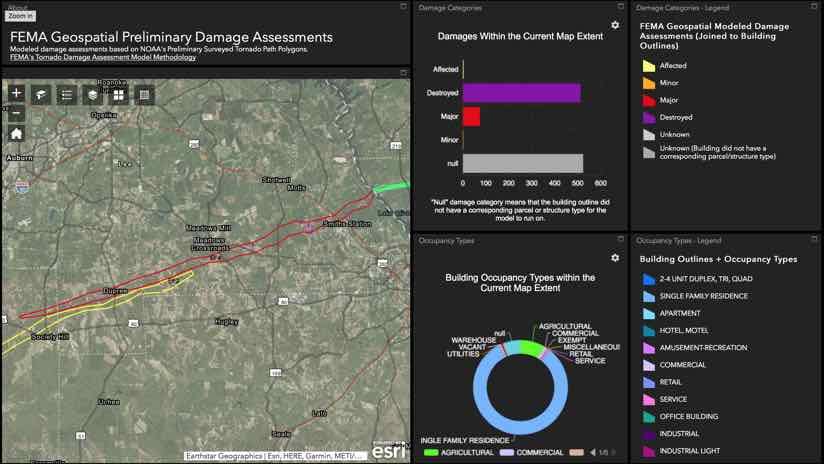
“The preliminary model takes land use data within the tornado track to estimate the level of damage to individual structures,” said Madeline Jones, geophysical data scientist at New Light Technologies, a FEMA contractor. “As soon as we have wind speeds, we can run the model to calculate the estimated level of damage. From there, we can create a spreadsheet, stand up a web application, and create a feature service that others can consume, all within a few hours.”
Speedy assessment enhances situational awareness for teams conducting on-the-ground damage analysis as well as crews working to remove debris, reopen roadways, and restore electrical and communications networks. The preliminary damage review also helps support damage declaration decisions for the impacted communities.
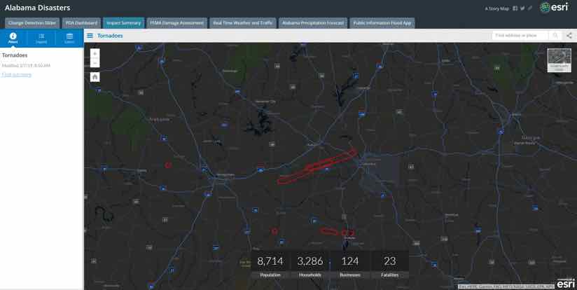
This tabbed Story Map was developed by the Alabama Law Enforcement Agency. This first tab shows tornado paths and tallies the people and businesses impacted.
Combining Many Inputs
Many people and agencies rally to assist local first responders during each disaster. In the case of the Alabama tornadoes, the American Red Cross rapidly deployed volunteers to conduct door-to-door damage assessments with a survey-based field application. The Geospatial Intelligence Center (GIC) of the National Insurance Crime Bureau, through a partnership with Vexcel Imagin, collected aerial imagery.
With today’s modern geospatial infrastructure, data from multiple organizations can be securely shared as web services. This includes web services for aerial imagery, field-collected data, base maps, and more. Together, these data can be combined in purpose-built applications that visually communicate different place-based aspects of the operation.
“The model provides an estimated overall scoping of the incident size, shape, and extent to support a variety of crisis decisions,” Vaughan [FEMA GIO] said. “The faster and more accurate we are, the better the evidence-based decisions. We’re always fighting time, and time is life.”
NLT is a 15-year ESRI Business Partner with a diverse background in working with ESRI across multiple jurisdictions including Federal, State, and Local Governments. NLT has worked with ESRI over the years bringing ESRI technologies to dynamic customer environments and integrating solutions from multiple data and infrastructure systems with great success.
New Light Technologies, Inc. (NLT) provides comprehensive information technology solutions for clients in government, commercial, and non-profit sectors. NLT specializes in DevOps enterprise-scale systems integration, development, management, and staffing and offers a unique range of capabilities from Infrastructure Modernization and Cloud Computing to Big Data Analytics, Geospatial Information Systems, and the Development of Software and Web-based Visualization Platforms.
In today’s rapidly evolving technological world, successfully developing and deploying digital geospatial software technologies and integrating disparate data across large complex enterprises with diverse user requirements is a challenge. Our innovative solutions for real-time integrated analytics lead the way in developing highly scalable virtualized geospatial microservices solutions. Learn more about NLT and our Services or contact us in times of emergency.
Parts of this blog were originally published on April 23, 2019 in the ESRI’s Blog by Esri’s Director of Public Safety Industry Solutions: Ryan Lanclos
NLT collaborates with General Assembly to train the next generation of data scientists for disaster response and management.
Tim Kuhn
Apr 7, 2019
Get notified on new blog posts
Stay updated with the latest insights and innovations from our experts. Subscribe now to receive exclusive content, industry updates, and behind-the-scenes looks at our team's work.