Reflecting on Another Event Facilitating Regional Collaboration, Share, and Advancement of Geospatial Innovation in the DMV
The DMV GIS Day 2025: Midpoint Meetup, held on April 30, 2025, served as an engaging follow-up to the successful DMV GIS Day 2024. This virtual event convened a vibrant geospatial community to highlight the significant impact of Geographic Information Systems (GIS) and the innovative advancements shaping progress throughout the District of Columbia, Maryland, and Virginia (DMV) region.
The midpoint meetup showcased the diverse network of GIS professionals, organizations, and enthusiasts who are applying cutting-edge geospatial technologies to address real-world challenges. Continuing the powerful, collaborative, and transformational spirit of DMV GIS Day, this event featured demonstrations of innovative applications, reviews of technological advancements, discussions on insightful topics, and presentations of compelling GIS projects.
About The Event
An Exciting Introduction:
Mario Field kicked off the event with welcoming remarks, outlining the day's agenda, discussing the objectives and goals of DMVGIS, and offering a sneak peek of the upcoming DMV GIS website. Following this, Adam Simmons spoke about Project Geospatial and its significant impact on how GIS is presented and communicated to a broader audience. He then highlighted the upcoming FOSS4G conference, scheduled to take place in Reston, Virginia, from November 3rd to 5th, emphasizing its value and relevance for the DMV GIS community.
Keynote Spotlight: OpenStreetMap and Government
Maggie Cawley, the Executive Director of OpenStreetMap US, delivered the keynote address that provided an in-depth look at OpenStreetMap US. This extensive open-source geodatabase encompasses a vast array of features across the United States, including trails, streets, businesses, and transportation routes. Her presentation emphasized that OpenStreetMap is a program and vibrant community dedicated to providing and maintaining free geospatial data, which powers thousands of maps and applications globally. She talked about a pertinent component of this community, which is the government working group, comprising over ninety representatives focused on fostering mutually beneficial relationships between the public, government entities, and open data initiatives.
This keynote underscored the significant potential and transformative power of open-source GIS data in enabling informed decision-making and enhancing operational efficiency across diverse fields. It highlighted the necessity of an engaged and dedicated community to effectively create, maintain, and disseminate geospatial data for widespread use through an open-source model, maximizing its impact.

Watch DMV GIS Day | Keynote: OpenStreetMap and Government - Maggie Cawley
Lightning Session 1: Simplifying Data Integration Using Postgres
Adam Timm from Crunchy Data presented the value and power of Postgres, highlighting its ability to operate as a robust data warehouse, through Crunchy Data Warehouse, as well as function as a traditional transactional data system. He explained how incorporating enhancements, such as a vectorized query engine coupled with a data lake, can significantly extend Postgres's functionality, transforming it into a versatile and high-performance data warehousing solution. By integrating data lake capabilities, open data formats, an adaptive query engine, and efficient data pipeline processing, Postgres evolves into a powerful database system and service.
Watch DMV GIS Day | Lightning Talk: Simplifying Data Integration Using Postgres - Adam Timm
Session 1: Enterprise Address Management
Mario Field from New Light Technologies underscored the necessity, importance, and potential of address data, illustrating how organizations can benefit significantly from establishing a single, authoritative source of location information. He detailed the key components of an enterprise address framework—including the database, map layers, maintenance application, and web services—and explained their synergistic function in delivering a comprehensive, adaptable, and efficient location reference. The presentation emphasized that effective address management extends beyond mere data; it encompasses the underlying structure and supporting services that facilitate the seamless use and integration of addresses across relevant organizational business systems and operations.

Watch DMV GIS Day | Session 1: Enterprise Address Management - Mario Field
Lightning Session 2: What’s Past is Prologue: A Geospatial Lens in Disaster Forecast Mapping
The second lightning talk featured Nate Smith from Upslope Advisors, who highlighted the substantial power and utility of GIS in disaster forecast modeling. He referenced the critical need to develop an event driven and tailored hurricane prediction model to inform agency decision-making. By analyzing the impacts and interventions from comparable past events, a customized approach can be modeled to best represent and effectively address the current disaster. Furthermore, the integration of geospatial demographic and infrastructure data serves to refine and enhance the model, thereby expanding response capabilities.

Watch DMV GIS Day | Lightning Talk - What's Past is Prologue - Nate Smith
Session 2: Vibes to Comfort Driven: Building a Bike Comfort Map
Matt Holden from Arlington County, Virginia, detailed the process of creating a bike comfort map for Arlington residents. He began by providing an overview of Arlington County and defining the purpose of a bike comfort map. He then discussed the methodologies and data sources employed in its development and outlined future steps aimed at improving the map and increasing public engagement. The presentation showed that the project's goals included streamlining bike map updates, offering multiple digital access options, and transitioning comfort rating definition to a more objective approach.

Watch DMV GIS Day | Session 2 - Vibes to Comfort Drive: Building a Bike Comfort Map - Matt Holden
Open Discussion:
The ending session was moderated by Bill Dollins from Cercana Systems, LLC and presented an opportunity for the attendees to ask questions to the speakers, reflect on the themes and messages of the overall event, and promote feedback and interaction among the group.

Watch DMV GIS Day | Open Discussion and Review - Bill Dollins
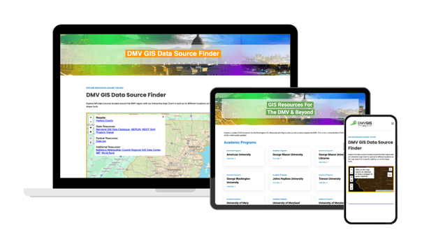
Stay Tuned for the DMVGIS Website launch:
NLT is excited to announce the upcoming launch of the DMV GIS website, anticipated towards the end of May. This online platform will serve as a central and valuable hub for GIS resources, data, and events relevant to the DMV region. The website will feature:
- GIS Resources: A curated collection of links to regional GIS-focused academic programs, and professional groups and associations.
- Data Source Map Viewer: An interactive map-based tool enabling users to select an area by clicking or drawing, which will then display relevant regional data sources from local, state, and federal government agencies, as well as NGOs and regional organizations.
- Comprehensive Event Calendar: A regularly updated calendar showcasing pertinent GIS events, including local meetups, significant national conferences, and general professional GIS events of interest to the DMV GIS community.
In Conclusion
The DMV GIS Day: Midpoint Meetup highlighted the remarkable talent, creativity, and dedication within our regional geospatial community. Looking ahead, we remain steadfast in our commitment to supporting this dynamic community and exploring the boundless potential of GIS to tackle global challenges and drive significant positive change.
For updates on our work and future events, follow us on LinkedIn, Twitter, and Instagram. Let’s continue exploring and advancing geospatial technology together!
Acknowledgments
We extend our heartfelt thanks to all speakers, panelists, and contributors, including:
Speakers: Maggie Cawley, Nate Smith, Mario Field, Adam Timm, Nate Smith, Adam Simmons, Matt Holden, Ghermay Araya. And Bill Dollins.
Event organizers: Griff Volker, Erin Chute, Kari Primiano, and Mario Field.
Participating organizations: New Light Technologies, Inc. (NLT), Cercana Systems LLC, Upslope Advisors, OpenStreetMap US, Project Geospatial, Crunchy Data, and Arlington County, VA.
Attendees who made DMV GIS Day: Midpoint Meetup a resounding success.
Further Reading
Check out Project Geospatial's coverage of the DMV GIS Day: Midpoint Meetup for more insights!
About New Light Technologies (NLT)
NLT is a leading provider of integrated science, technology, and mission services with over 20 years of experience serving government and commercial organizations. Offering renowned expertise in cloud, agile software development, cybersecurity, data science, geospatial, and remote sensing, NLT provides comprehensive consulting, research, digital transformation services, and fit-for-purpose analytics solutions for various industries, from emergency management to economics to health. NLT offers distinctive capabilities in delivering secure cloud-native platforms and web-based decision support tools and has pioneered predictive disaster risk analytics in support of homeland security missions. To learn more, visit www.NewLightTechnologies.com