DMV GIS Day: Midpoint Meetup
Celebrating The Geospatial Innovation Journey in
Washington, D.C., Maryland, and Virginia
Be part of the conversation shaping the future of GIS in the DMV region. Stay tuned for more details and registration information.
VIRTUAL EVENT
Registration is FREE for all!
Join us for DMV GIS Day 2025: Midpoint Meetup
Continuing To Shape The Future of GIS Together.
Join us for DMV GIS Day 2025: Spring Meeting where the dynamic geospatial community of the Washington, D.C., Maryland, and Virginia (DMV) region comes together to showcase the history, latest innovations, applications, and trends in Geographic Information Systems (GIS). This half-day event highlights the diverse ecosystem of GIS professionals, organizations, and enthusiasts working to solve real-world challenges using cutting-edge geospatial technologies in our community.
New Light Technologies
April 30, 2025
10:00am - 12:00pm ET
Virtual
Who Should Attend?

Who Should Attend?
This event is designed for anyone passionate about geospatial technology, including GIS professionals, government officials, educators, students, technology enthusiasts, and participants from commercial organizations, non-profits, and international organizations. Whether you're a seasoned expert or new to GIS, DMV GIS Day: Midpoint Meetup offers something for everyone.
Why Attend?

Why Attend?
- Expert Insights: Learn from keynote speakers and panelists who are leading the charge in geospatial innovation across government, academia, and industry.
- Cutting-Edge Technology: Discover how GIS is being used in public safety, urban planning, environmental sustainability, and more.
- Networking Opportunities: Engage with fellow GIS professionals, students, educators, and leaders from around the DMV region and beyond.
- Free Access: This is a FREE event for all attendees, offering unparalleled access to knowledge and networking.
How To Participate.

How To Participate.
Register Now! Join virtually from anywhere to access sessions, workshops, and networking opportunities. Registration is FREE for all!

Who Should Attend?
This event is designed for anyone passionate about geospatial technology, including GIS professionals, government officials, educators, students, technology enthusiasts, and participants from commercial organizations, non-profits, and international organizations. Whether you're a seasoned expert or new to GIS, DMV GIS Day: Midpoint Meetup offers something for everyone.

Why Attend?
- Expert Insights: Learn from keynote speakers and panelists who are leading the charge in geospatial innovation across government, academia, and industry.
- Cutting-Edge Technology: Discover how GIS is being used in public safety, urban planning, environmental sustainability, and more.
- Networking Opportunities: Engage with fellow GIS professionals, students, educators, and leaders from around the DMV region and beyond.
- Free Access: This is a FREE event for all attendees, offering unparalleled access to knowledge and networking.

How To Participate.
Register Now! Join virtually from anywhere to access sessions, workshops, and networking opportunities. Registration is FREE for all!

Maggie Cawley
Executive Director
OpenStreetMap US
Keynote Speaker
Maggie Cawley serves as the Executive Director for OpenStreetMap US, a nonprofit organization dedicated to advancing the democratization of geospatial data by catalyzing collaborative action around OpenStreetMap between individuals, government agencies, nonprofits, corporations, and academia. With a background in urban planning, GIS, and community engagement, Maggie is passionate about leveraging the power of open data and open source technology to create more inclusive and innovative solutions for various industries. She is a strong advocate for open data and collaboration, and works tirelessly to build partnerships and drive initiatives that make mapping accessible and impactful for all. Maggie also serves as the Chair of the National Geospatial Advisory Committee, where she works to foster the innovation and collaboration that is critical in shaping and advancing national geospatial policy and initiatives for the benefit of society. She holds a MA in Urban and Regional Planning from Virginia Commonwealth University and a BA in International Studies from the University of Richmond.
Session Speakers
Explore our discussion leaders and speakers below. Check out their speaker bios to learn more about these experts.
Bill Dollins
Nate Smith
Upslope Advisors
Mario Field
About Bill
Bill Dollins, founder and president of Cercana Systems LLC, is a recognized geospatial technology leader with more than 30 years of experience in designing, implementing, and managing geospatial systems. Bill provides strategic consulting focused on maximizing the value of data assets in verticals like broadband infrastructure, civil engineering, government services, and AI. A lifelong resident of the DMV region, Bill has been a leader in advancing best practices in open data, the integration of proprietary and open-source geospatial software, and the development of high-performance teams. His expertise in fusing geospatial technologies with enterprise systems has helped public and private sector clients maximize value and gain new insights from their data.
Previously, Bill served as Chief Information Officer at Fulcrum, where he led IT, data operations, and professional services teams. He achieved significant milestones in developing data infrastructure, expanding revenue, and ensuring security compliance. At Zekiah Technologies, as Partner and Senior Vice President, Bill managed programs and technology strategies for critical projects, including infrastructure protection for the US Navy and the Department of Homeland Security. Bill was also a founding member of the Homeland Infrastructure Foundation-Level Data (HIFLD) working group, which continues to provide high-value geospatial data to the infrastructure protection community. Bill’s expertise in geospatial technologies, data operations, and leadership has positioned him as a key contributor to the advancement of geospatial solutions across multiple industries.
About Nate
Since 1992 Nate Smith has worked at the confluence of geospatial information and disaster management in both the domestic and international domains. He has been an innovator and pioneer though his work at USAID's Office of Foreign Disaster Assistance, FEMA's GIS Solutions Branch, the DHS Geospatial Management Office and the Defense Threat Reduction Agency. He currently works for UpSlope Advisors supporting the Small Business Administration. He refined his knowledge of operational requirements through work as a local first responder, international humanitarian, and his work consulting for a number of disaster management agencies. He continues to share his knowledge and experience in applying GIS solutions to emergency management through courses developed and delivered at several Universities (GWU, FIU, UMBC) and with Bootcamp GIS. He holds a degree in Geography from UMBC and earned a master’s in urban and Regional Planning from Virginia Tech.
About Mario
Mario Field is a seasoned GIS professional with a deep-rooted presence in the DMV community. He has been instrumental in driving the adoption and innovation of geospatial technologies and services. Throughout his career, Mario has focused on developing geospatial infrastructure, managing data governance, and promoting GIS adoption across local and federal government agencies
In recent years, Mario has expanded his expertise into the data domain and cloud environment. He has led data management initiatives, including data warehousing, data integration, data quality assurance, and data platform operation. His foremost goal is to empower organizations by leveraging data for advanced analytics, enhanced mission delivery, improved operations, and increased efficiency. He has successfully implemented these strategies in the USPS domain, serving as Chief Data Officer at the Postal Regulatory Commission (PRC) and Enterprise Data Manager at the USPS Office of the Inspector General.
Despite his recent focus on data, geospatial data and technology remain Mario's primary passion. Reflecting this, one of his first initiatives at the Postal Regulatory Commission was to establish an enterprise GIS service to enhance business decision-making and operational outcomes.
Mario recently moved to Charlotte, North Carolina, where he's embracing the even hotter weather, southern charm, and sweet tea. Although he's changed sports markets, he remains a dedicated fan of the Baltimore Ravens and Virginia Tech Hokies.
Ghermay Araya
Adam Timm
Crunchy Data
Matt Holden
About Ghermay
Ghermay Araya is the Founder and CEO of New Light Technologies, Inc. (NLT), a Washington, DC-based company with over 23 years of experience delivering mission-critical geospatial and data solutions to public and private clients. Ghermay holds both a BS and MS in Geographic Information Systems (GIS) from the University of Maryland, College Park, and is currently pursuing a Ph.D. in Earth Systems and Geoinformation Sciences at George Mason University. He has attended Harvard Business School’s Executive Education program to enhance his Disruptive Innovation architecture for NLT. With deep roots in the DC GIS Program’s early implementation, he has been instrumental in shaping the region’s geospatial landscape, supporting numerous organizations across the DC and Maryland geospatial community.
As a mission-oriented IT executive with extensive experience in enterprise information technology, Ghermay has successfully transformed NLT into a leading provider of GIS, IT, and Data Science services. He has worked across various sectors, including space, defense, academia, and civil engineering, serving as a consultant, data analyst, software developer, and instructor. In his leadership role, Ghermay leverages a unique blend of business development and technical expertise to guide NLT’s diverse clientele, which includes Federal, State, and Local Governments, as well as academic and non-profit organizations. He holds certifications such as GISP from GISCI and CSM from the Scrum Alliance, and has also led initiatives like GIS workforce development, address standardization, and implementing reliable GIS infrastructure—earning the NACIO Best of the Web award alongside his colleagues.
Ghermay has also been deeply involved in education and geospatial community organizing and events and serving as a lecturer at the University of Maryland’s MS GIS program, where he teaches Spatial Databases. He continues to lead teams across various technology projects, fostering sustainable solutions through lean business development and innovation strategies, and ensuring that NLT remains a prominent force in the geospatial and IT sectors.
About Adam
Adam Timm is an Air Force vet, former Intelligence Officer, and now an open source advocate. He has experience with Government Acquisitions, satellite and airborne Intelligence, Surveillance, and Reconnaissance systems, Digital Transformation initiatives, and now driving adoption of open-source software in the DoD and Federal Government. He currently lives in WI with his wife and four children.
About Matt
Matthew Holden is a GIS Analyst and Data Management Specialist with the Transportation Operations & Engineering Bureau (TE&O) at Arlington County, Virginia working on asset management and transportation safety through the county’s Vision Zero Program. He has worked in the Geospatial industry for over a decade with experience in environmental planning, land use management, transportation planning and operations. Prior to joining the Transportation Operations & Engineering Bureau at Arlington County, he worked for the District of Columbia of Zoning, developing mapping applications and working on the first comprehensive update to the District’s Zoning Regulations since 1956.
Agenda
Check back here to learn about the insightful sessions that await! Schedule is subject to change.
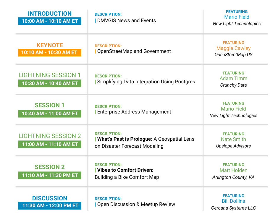
|
INTRODUCTION |
DESCRIPTION: |
FEATURING: |
|
KEYNOTE |
DESCRIPTION: |
FEATURING: |
|
|
DESCRIPTION: |
FEATURING: |
|
SESSION 1 |
DESCRIPTION: |
FEATURING: |
|
|
DESCRIPTION: | What’s Past is Prologue: A Geospatial Lens on Disaster Forecast Modeling |
FEATURING: Nate Smith Upslope Advisors |
|
SESSION 2 |
DESCRIPTION: | Vibes to Comfort Driven: Building a Bike Comfort Map |
FEATURING: |
|
DISCUSSION |
DESCRIPTION: |
FEATURING: |


